


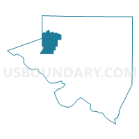
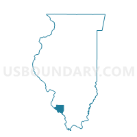
RUMA Voting District, Randolph County, Illinois
About
Outline

Summary
| Unique Area Identifier | 574048 |
| Name | RUMA Voting District |
| County | Randolph County |
| State | Illinois |
| Area (square miles) | 22.91 |
| Land Area (square miles) | 22.84 |
| Water Area (square miles) | 0.07 |
| % of Land Area | 99.68 |
| % of Water Area | 0.32 |
| Latitude of the Internal Point | 38.12057230 |
| Longtitude of the Internal Point | -89.99268980 |
Maps

Graphs
Select a template below for downloading or customizing gragh for RUMA Voting District, Randolph County, Illinois


Neighbors
Neighoring Voting District (by Name) Neighboring Voting District on the Map
- BREWERVILLE Voting District, Randolph County, IL
- EVANSVILLE Voting District, Randolph County, IL
- PRAIRIE-DU-ROCHER Voting District, Randolph County, IL
- PRECINCT 9, Monroe County, IL
- RED BUD 1 Voting District, Randolph County, IL
- RED BUD 4 Voting District, Randolph County, IL
Top 10 Neighboring County Subdivision (by Population) Neighboring County Subdivision on the Map
- Red Bud precinct, Randolph County, IL (4,692)
- Evansville precinct, Randolph County, IL (1,015)
- Prairie du Rocher precinct, Randolph County, IL (974)
- Precinct 9, Monroe County, IL (972)
- Ruma precinct, Randolph County, IL (817)
- Brewerville precinct, Randolph County, IL (285)
Top 10 Neighboring Place (by Population) Neighboring Place on the Map
Top 10 Neighboring Elementary School District (by Population) Neighboring Elementary School District on the Map
Top 10 Neighboring Secondary School District (by Population) Neighboring Secondary School District on the Map
Top 10 Neighboring Unified School District (by Population) Neighboring Unified School District on the Map
Top 10 Neighboring State Legislative District Lower Chamber (by Population) Neighboring State Legislative District Lower Chamber on the Map
Top 10 Neighboring State Legislative District Upper Chamber (by Population) Neighboring State Legislative District Upper Chamber on the Map
Top 10 Neighboring 111th Congressional District (by Population) Neighboring 111th Congressional District on the Map
Top 10 Neighboring Census Tract (by Population) Neighboring Census Tract on the Map
- Census Tract 9508, Randolph County, IL (4,653)
- Census Tract 9509, Randolph County, IL (3,598)
- Census Tract 6005.02, Monroe County, IL (3,338)